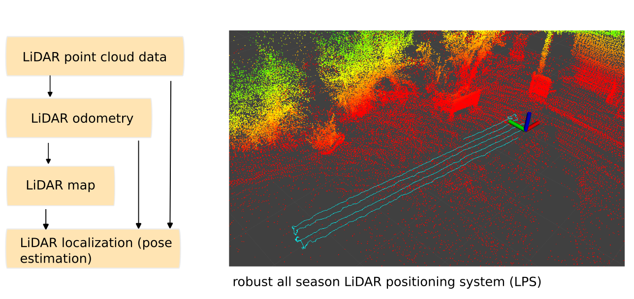
Robust All-season LiDAR Positioning System (LPS)

Die meisten LiDAR basierten Positionierungssysteme sind für den Indoor Einsatz konzipiert und versagen bei umfangreichen Änderungen der Umgebung, was im Indoor Bereich selten ist.
Im Outdoor Einsatz ist es jedoch wichtig dass die lokale Ortung auch bei veränderter Umgebung eine präzise Ortsbestimmung. Alleine durch die sich stetig ändernde Vegetation, durch Baumbeschnitt und mähen von Gras ändert werden markante Punkt der Karte evtl. verdeckt und neue entstehen. Das alles muss ein LiDAR basiertes Outoor Positionierungssystem über die Zeit erkennen und handhaben können.
Auf diese, spezielle „Ganzjahresfähigkeit“ ist unser owlLPS ausgelegt.

Features:

  • requires only a low-cost LiDAR (e.g. Livox MID-360 or LSLIDAR-C16)
  • high-precision 3D LiDAR odometry (typical +/- 2cm)
  • outdoor and indoor across several floors (small and large 3D areas with thousands of square meters, across floors)
  • robust localization system (localization works between seasons, e.g. localization at winter time against a summer map and vice versa with typical localization accuracy +/-10cm in changing outdoor environments and +/-2 cm in static environments)
  • optionally, GPS-RTK can be added to improve localization performance in very open areas (>100m) with no objects in the environment (alternatively, objects like traffic cones can be added to very open areas for LiDAR-only localization) 
  • based on open source code (robotic operating system ROS)


There is no translation available.

To make the best use of resources and thus save money at the end of the day, you need to know what the current state of your infrastructure is. The owl Robotics Sensor Value Mapping helps to measure values on an area and to display them with centimeter accuracy in a map of the area, as a heat map.
With this precise representation, for example, a farmer can optimize the use of fertilizer in the field, a company can ensure the coverage of his wireless network on the company premises, a fruit grower can optimize the use of his irrigation system to save water and many other applications.
The navigation hardware and software can be installed in an autonomous robot that permanently scans the surfaces and determines the values, or on any other vehicle that can be used to take measurements, such as a forklift that measures the permanent WiFi quality in a warehouse or the quality of the air.

heatmap.jpg

About owlRobotics GmbH

owlRobotics GmbH stands for high precision navigation algorithms for self driving robots like lawn mowers and similar vehicles, based on our Sunray-OS or open standards.

Wir benutzen Cookies

Wir nutzen Cookies auf unserer Website. Einige von ihnen sind essenziell für den Betrieb der Seite, während andere uns helfen, diese Website und die Nutzererfahrung zu verbessern (Tracking Cookies). Sie können selbst entscheiden, ob Sie die Cookies zulassen möchten. Bitte beachten Sie, dass bei einer Ablehnung womöglich nicht mehr alle Funktionalitäten der Seite zur Verfügung stehen.